
(Note: This report up has been prepared with the help of grok.com and it appears to be very realistic- SR Darapuri, National President, All India Peoples Front)
Possible Causes of Severe Floods in Punjab

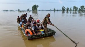
(Asian independent) Punjab, a fertile region spanning parts of northern India and eastern Pakistan, is highly susceptible to flooding due to its geography, river systems, and seasonal weather patterns. The area is crisscrossed by major rivers from the Indus basin, including the Sutlej, Beas, Ravi, Chenab, and Jhelum, which originate in the Himalayas and carry massive water volumes during the monsoon season (typically June to September). Floods in this region can affect both Indian Punjab and Pakistani Punjab, often simultaneously, as seen in the devastating 2025 floods that impacted hundreds of thousands across the border. Below, I’ll outline key causes based on recent and historical patterns, drawing from environmental, climatic, and human factors.
- Heavy Monsoon Rainfall and Extreme Weather Events
– Intense and prolonged monsoon rains are the primary trigger for floods in Punjab. In 2025, northern India and Pakistan experienced some of the heaviest rainfall in decades, with Punjab receiving up to 74% more rain than average in August alone. This led to rapid swelling of rivers like the Sutlej, Beas, Ravi, and Ghaggar, submerging vast farmlands and villages.
– Upstream rainfall in Himalayan states/regions (e.g., Himachal Pradesh, Jammu & Kashmir in India, or northern Pakistan) exacerbates downstream flooding in Punjab’s flat plains, where water has nowhere to drain quickly.
– Climate change has intensified these events, making monsoons more erratic and deadly. Studies indicate that global warming increases the likelihood of heavy downpours, leading to more frequent landslides and flash floods in the region.
- River Overflow and Poor Water Management Infrastructure
– Punjab’s rivers often overflow due to siltation (buildup of sediment reducing river capacity), breaches in embankments, or sudden releases from upstream dams during peak rains. For instance, in 2025, controlled releases from dams like Pong and Bhakra in India contributed to downstream inundation in Indian Punjab.
– In Pakistan’s Punjab, similar issues arise with barrages and canals failing under pressure, as seen when the Ravi River flooded urban areas like Lahore. Historical floods, such as those in 2022, highlight inadequate flood barriers and early warning systems.
– Flat topography in Punjab acts as a natural “sink,” where water pools easily, prolonging floods and causing widespread crop damage (e.g., over 175,000 acres submerged in Indian Punjab in 2025).
- Human and Developmental Factors
– Urbanization, deforestation, and encroachments on riverbanks reduce natural absorption and narrow floodplains, worsening runoff. In both Punjabs, illegal constructions along rivers have blocked drainage channels.
– Agricultural practices, including over-irrigation and poor land management, contribute to soil erosion and reduced water retention.
– Inadequate infrastructure, such as outdated drainage systems and delayed evacuations, amplifies impacts—nearly 1 million people were evacuated in Pakistan’s Punjab in 2025 alone.
These causes are interconnected, with climate change acting as a multiplier for natural and human-induced vulnerabilities.
Relation to the Ongoing Indus Water Treaty Dispute
The Indus Waters Treaty (IWT), signed in 1960 and brokered by the World Bank, allocates water from the Indus River system between India (control over eastern rivers: Sutlej, Beas, Ravi) and Pakistan (western rivers: Indus, Jhelum, Chenab). It was designed to prevent conflicts, including India’s potential to cause floods or droughts in Pakistan by manipulating upstream flows. However, the treaty has been under strain due to disputes over Indian dam projects (e.g., on the Chenab and Jhelum), climate pressures, and geopolitical tensions.
– Direct Links to Floods? There are accusations, particularly from Pakistan, that India’s actions amid the dispute have exacerbated floods in Pakistan’s Punjab. In 2025, Pakistan blamed India for “weaponizing water” by suspending the treaty after a militant attack, allegedly leading to unannounced water releases from Indian dams that worsened downstream flooding. For example, breaches at barrages on the Ravi River were linked to India’s failure to share real-time hydrological data or provide proper flood warnings, violating treaty protocols.
– India’s Perspective and Expert Views: India denies deliberate flooding, attributing events to natural causes like heavy rains, and has accused Pakistan of not maintaining its infrastructure. Experts emphasize that while the dispute hinders cooperation (e.g., data sharing), the primary driver of 2025 floods is climate change, not intentional sabotage. The treaty’s suspension has raised fears of worse future crises, as it removes mechanisms for joint flood management.
– Impact on Indian Punjab: The dispute has less direct bearing here, as floods stem more from internal Indian river management and upstream rains within India. However, broader tensions could indirectly affect bilateral efforts to address shared climate risks in the Indus basin.
In summary, while the IWT dispute has fuelled blame and reduced cooperation—potentially aggravating floods in Pakistan’s Punjab through poor data sharing or unmanaged releases—the core causes remain climatic and infrastructural. Strengthening the treaty could help mitigate future risks for both sides.
Courtesy: grok.com


