
Hardwar to Garhmukteshwar
-Vidya Bhushan Rawat
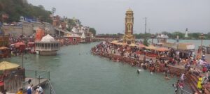
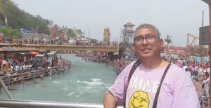
(THE ASIAN INDEPENDENT) After the Himalayas, Ganga descend to Rishikesh followed by Hardwar which is an extremely important pilgrim town of Uttarakhand state. It is called city of Lord Shiva and host Kumbha fair once in 12 years in which millions of devotees participate and take a holy dip into the river. The Ghats are ‘Har ki Pairi look stunning and magnificent. About twenty kilometres from this place, Ganga, at the place called Balawali, enters Uttar Pradesh.
First railway bridge on Ganga was built here by the British. The 961 meter long bridge was constructed in 1888 at the cost of Rs 27 lakh 94 thousand rupees[1] linking Laksar to Najibabad, a railway junction in district Bijnaur.Balawali is a small village near Laksar town of Hardwar district. The crisis of Ganga start from Hardwar itself where water is diverted to Upper and Lower Ganga canal through Bhimgoda Barrage. The original river which move ahead has lesser water than these canals. The diversion of water to ‘ Har ki Pairi’ ensure heavy flow to respect the religious sentiments of the people. The barrage was originally conceived by the British for the purpose of irrigation through Upper Ganga Canal as well as to control flooding, between 1840-1854 but finally completed in 1983.

Though Hardwar is part of Uttarakhand state, it is also the ‘door’ of Ganga for the plains of Northern as well as Eastern India. The original river with much reduced water is a pale shadow of the powerful river we see either in Rishikesh or at Har ki Pairi. Rishikesh has become favourite destination for the rafters but the dark fact is water in Ganga is not natural and solely depend on the Tehri dam. At the Lakshman Jhula, the famous suspension bridge is closed as it is undergoing through maintenance work. Once you go to river bank, you find the sudden disappearance of sandy beach which was the hallmark of beautiful banks of river Ganga. Instead, you find Himalayan concrete, stones and big boulders. And the similar situation remain till Ganga crosses the famous Chandighat bridge linking Hardwar with Najibabad by road link. It is also the beginning of the Gangetic plains which used to be extremely fertile once upon a time but today we see vast fertile land turning into desert. At about 45 kilometers from Najibabad town is the famous barrage on Ganga in the Bijnor district.
‘Water quality in mountainous stretch Ganga is very good, with high DO levels Avg. 8.17∓0.4, low EC, TDS and TOC, indicating no significant contamination pollution. When Ganga enters in Uttar Pradesh the first station is Bijnor before this many small rivers and the sub-basins are merge in Ganga. The STPs reduce 61–93 % organic loadings and half of trace contaminants present in the sewage (CPCB-2009). Domestic sewage is the major contributor of pollution in this stretch. The water quality in the stretch is affected from the Rishikesh (Uttarakhand) by domestic, industrial organic and inorganic west and agricultural runoff.’’[2] The same paper actually suggest that water get cleaned due to floods in monsoon.
The bridge on barrage on Ganga near Mirapur-Bijnor eased the journey from Najibabad to Delhi particularly for those who were coming from Uttarakhand’s Garhwal regioncame into operation in 1984. Bijnor see numerous rivers flowing such as Ramganga, Kho and others. There is a big dam on Ramganga river at a place called Kalagarh but a dark reality is that various dams and barrages are just killing the soul of river Ganga. Unfortunately, the growing ‘artificiality’ of controlling water on various rivers reflect an increasing pattern of addressing the religious ‘sentiments’ and encouraging ‘’tourism’ around these places hence flow of water depend on whether there is some specific period or not. The bridge over barrage basically is the border line between Bijnor and Mujjaffarnaar district. There are plans so start boating and other water sports here in the barrage but the water level in the river reduces drastically. The only time the Ganga look as a river is in monsoon when these barrages are unable to keep the water and the powerful water change its embankment and bring huge amount of sediments. Interestingly, the Gangetic embankment in Hardwar and Rishikesh are full of stones and sediment everywhere as the size of the river reduces drastically. One of the locals explained it to me in Kanpur recently during my Ganga yatra that when the river has enough water it moves fast on its direction but as the water level reduces the size of the river grows extraordinarily. During the monsoon, water enter into the lower areas flooding everywhere and when the monsoon is over and water recedes it create numerous islands, splitting the river most of the time and changing embankment.
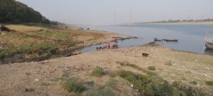
A travel from Bijnor to Balawali and Laksar shows how the entire Ganga belt is suffering in extreme heat with polluted air filled with dust and other particles. From Bijnor, the next important places on the bank of the river is Garhmukteshwar which is part of Hapur district. Garh, as it is popularly known as, is hugely popular pilgrim centre after Hardwar and thousands of people come here to take a dip in the river Ganga on Ganga Dushara day. There is a huge railway bridge over the river apart from the National Highway 8 linking Delhi to Lucknow via Moradabad, Bareilly and Sitapur. There is a temple on the bank of Ganga and bathing ghats. Hundreds of boats waiting for customers. The water level has reduced drastically, says a boatman. Sir, we have lesser customer these days. A boat ride gives us the idea of the crisis as we pass underneath the highway bridge and then move to the other side where pilgrims comes for performing shraddha and other rituals unmindful of the crisis the river is facing.
Garh falls under Hastinapur sanctuary spread over five districts of Bijnor, Mujaffarnagar, Meerut, Hapur and Amroha. 2073 square kilometre sanctuary is now reduced to 1095 square kilometer as vast land was needed for railways and national highway projects.[3]
Ramganga-Ganga Sangam Hardoi
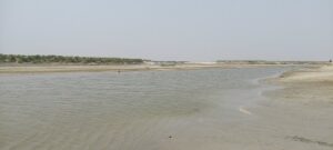
The next big place where Ganga is strengthened by various tributaries is district Hardoi where Ramganga flows into it in a place called Teraghat or Terapursoli near Sandi Shahbajpur in Tehsil Devkali. A visit to the sangam was extremely difficult. A three hours drive from Kanpur to Kannauj and then nearly five kilometres from the Bridge over Ganga that serves as boundary between Hardoi and Kannauj. The irony is that there is not much understanding about Sangam and the possible reason for the same seems to be the changing embankment of Ganga particularly during the monsoon floods. Thousands of hectares of land get inundated as the flooded rivers explore new areas brining enormous sediments and therefore creating a huge agrarian crisis. Desertification of the fertile land is the biggest challenge but seems to be ignored by the policy planners. At the point zero there is a debate among two fisherfolks whether this is Sangam or not because all the rivers are split and their various streams meets at different points but from here till the big bridge, various small rivers to get discharged at the Ganga.
At the confluence area, I see an ‘island’ working as divider between Ganga and Ramganga with a small stream from Ganga passing into Ramganga while the main river moving further to meet again a few hundred meters away. Ramganga looks shockingly short of water which is around your knee. Initially, I thought of asking for a boat who could take us across the river but a local farmer who had just joined in, assures me that we could just cross over the river without any problem. I was still hesitant but with the help of this farmer I crossed over to see the confluence. A local person said this was the first confluence followed by second a few hundred meters away when the entire Ramganga flows into it.
As I walk back to cross the river, a herd of buffaloes walk through the river. It is scorching heat and temperature above 40 degree Celsius, the river provide shelter to these innocent cattle. The entire fertile land has become desert and the villagers are bringing their cattle for grazing though there is not much grass and the animals are just moving around and cooling in the river. A couple of farmers are sitting and watching their cattle. One of the young farmers accompanying me here informs me that ‘ab kheti khatm kewal reti hai’ i.e. There is no agriculture now. It is just sand mining and it reflect the growing reality of how farmers and fisherfolks are now depending more and more on sand mining. In the scorching heat, you wont even get a glass of water but thankfully the farmer got me a’tarbuz’ i.e. watermelon and a musk melon from his land nearby.
‘Desertification of arable land is the biggest challenge that Gangetic plains are witnessing. ‘As per the Desertification and Land Degradation Atlas of India, prepared by the Space Applications Centre for the period 2011-2013, 96.4 million hectares i.e. 29.32% of the Total Geographical Area of the country is undergoing the process of desertification/land degradation.Approximately 6.35% of land in Uttar Pradesh is undergoing desertification/degradation.’[4]
Uttar Pradesh’s Lakhimpur Khir, Sitapur, Bahraich, Barabanki, Ayodhya, Gonda, Basti, Azamgarh, Deoria, Balia, Gorakhpur districts face huge crisis of desertification. Every year, these districts suffer a lot because of huge flood in various rivers including Ganga, Ghaghara, Sarda, Rapti rivers which bring enormous silt and change their embankment.
Around seven small rivers including Ramganga merge into Ganga at Hardoi-Kannoj border but a look from the motor bridge show the water level is reduced and river split at different places with increasing sand beds on both the sides. Many tiny islands’ have been created due to this. Kannauj is around 10 kilometer from this bridge, a historical city of Harshvardhana period and later Jaichand was the most outstanding ruler of Kannauj but distortion of history ensured that the legacies of the great king are erased forgotten by the locals though when I asked a farmer on the Sangam area, who happened to be a Rajput, informed me that his community never considered kin Jaichand a villain and they remember him with great respect. Unfortunately, there are no signs of any memorial or historical places in his memory or that of Harshvardhana. There are however several Dargahs and mosques of 13th-14th centuries, during the period of Shahjahan.
The crisis at Kanpur
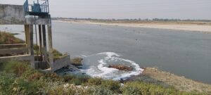
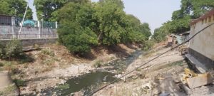
Kanpur Kannauj National Highway has reduced the time distance and linked these cities closely. At about 70 kilometers distance is a pilgrim town Bithoor. It is also a historical town related to 1857 war of independence. A memorial has been built here as a homage to Nana Saheb Peshwa s/o Bajirao Peshwa II, who made this place is headquarter. There are numerous ancient temples and ashrams here. For people of Kanpur, Bithoor is becoming a tourist spot and the reason for this is beautiful location on the right side of Ganga which look stunningly beautiful here. Unlike Kanpur, the Ganges look a complete river here and people come here for boating. The ghats too are relatively clean here. The reason for the water level better here is the barrage which is built on Ganga and control water for Kanpur city is just five kilometer from here. Immediately after the barrage, Atal Ghat is now the most sought after ‘picnic’ space at the Kanpur city. The project was developed under the Namami Gange schemes of the government of India and is relatively clean. Slogans are written on the board like ‘don’t throw garbage in Ganga’ or Watching Ganga itself is like bathing in it. The Ganga view here is beautiful and cross the river is Unnao district. Actually, Ganga forms the boundary between Kanpur and Unnao districts. About 50 meters adjacent to Attal Park is the infamous Permiya Nullah (Permiya drainage) flowing into the Ganga which is shocking as this ghat is developed beautifully and lots of slogans related to Gana cleanliness are written all over. Namami Gange project was publicised highly yet the Ganga water remain not only unfit for drinking but even for bathing. Water is contaminated and even the Central Pollution Control Board, Kanpur could not find fish in the river. Ganga water has dried up and frankly it is the sewage water which is flowing uncontrolled in the river. There are several important ghats and ‘drainage’ that flows into Ganga. Ranighat nullah, Seesamau Nullah near Bhaironghat, Guptarghat Nullah near Bhagwat Ghat. Most of these ghats are basically cremation ghats where all the filth, garbage is thrown in the river Ganga.
At Bhaironghat, I walked into the crematorium and then at the Ganges where river bank is simply flooded with thrown away items, flowers and other items for performing rituals. The water is definitely not worth touching but ‘holy’ ‘devotees’ still go and sprinkle the water over them. A couple of Boats used by the local fishing communities can be seen in the river. ‘Namami Gange’ is ‘loudly’ written all around. Just below it a huge cemented structure is visible which look like a gigantic river conflating with Ganga. It is Seesamau Nullah which was draining into the holy river. Sadly, a few years back, the story of this Nullah being closed and Ganga water being pollution free in Kanpur, was celebrated in various channel. ‘Now, it is reported that between May 25th till May 30th, about 40 crore liters of untreated sewage discharged into Gana at Seesamau drainage alone. A report in Hindi daily Hindustan informs that the Jal Nigam in Kanpur has imposed a fine of Rs 17 crore on Kanpur River Management Ltd. for its failure to control sewage drainage flowing into river Ganga. An FIR has also been registered against the company in the Gwal Toli police station.’[5] It is sad that the crisis in the Ganges is aggravating despite spending crores of rupees in the name of ‘Save Ganga’ or ‘Clean Ganga’ operations,
Kanpur is the biggest city of Uttar Pradesh and is home to over ‘402 listed tanneries though only 215 small and big are operational now.’[6] Unfortunately, the leather industry has lost in Kanpur not because of the ‘stringent’ environmental laws but ‘unavailability’ of raw material due to strict anti-cow slaughter laws. The sad part is that Kanpur’s industrial losses have not really helped resolve the crisis that Ganga is facing in the city.
The Ganga look dried as big islands are created and river split at many places with absolutely dirty embankment where not merely sewage drainage are discharging but other filthy stuff, rotten flowers and other items meant for performing various rituals. The historic railway bridge on Ganges between Kanpur and Unnao on Delhi-Kanpur-Lucknow line actually started on July 15th,1875. The drains and sewage system continue to pollute the holy river. Many reports and studies have red flagged the contamination of the Ganga water.
‘’The investigation conducted by the CPCB, led by Ajit Vidyarthi, Director and Department Head of Water Quality Management, spanned over three sampling dates – July 10, July 24, and August 22. The report reveals that a significant portion of the Ganga, stretching from Bithoor to Fatehpur in Kanpur, is now severely polluted, raising grave concerns among the residents and environmentalists.’’
Ganga and Yamuna at Fatehpur
[7]Interestingly, the river Ganga move towards Fatehpur, a very historic town represented by former prime minister V P Singh in 1989. A rural dominated constituency, Fatehpur has the distinction of both Ganga and Yamuna passing through it apart from Prayagraj where both the rivers reach and conflate after leaving Fatehpur. Other interesting point is that Ganga forms boundary of Unnao and Fatehpur too.
Bhitaura is located at about 15 kilometers from Fatehpur where river Ganga pass through. Across the river is district Unnao and Raibareilley is a few kilometers away on the same route. Bhitaura is mythologically an important place and number of pilgrims come here to take a dip in the river. Bhitaura is related to sage Bhrigu and a few ancient temples and ashrams are located nearby. At the Om ghat a number of pilgrims and tourists visit here and take a dip in the river. This area is also considered to be home of Dolphins too. Forest department has taken up the initiative in this regard to promote eco-tourism though we could not site any dolphin when visited the place. However, till a years ago siting Dolphin was a frequent thing which even researchers admitted.
“‘Nearly 35 km of stretch from Bhitora in Fatehpur has emerged as the region’s most congenial habitat for endangered Gangetic dolphins. The first ever headcount operation through sonar monitoring systems and camera-fitted balloons of the aquatic animals conducted recently, has come out with sighting of 19 dolphins.’ [8]
Though the Ganga ghats were relatively clean in Fatehpur, the district real crisis is with river Yamuna which suffer from heavy sand mining at the Chilla border which link Fatehpur to Banda. The roads are bumpy and risky due to heavy trucks carrying sand from the river bed. The air is polluted with sand particles being part of it.
The mega sangam at Prayagraj
Ganga looks enchanting when it has water and evening sun set time provide you stunning view of the river. It now move towards Prayagraj for the mega confluence with Yamuna at the historic ‘Sangam’ which is called ‘Triveni’ as apart from Ganga and Yamuna, the mythological legend is that river Saraswati too merge here. Thousands of devotees from different parts of the country visit this place, perform various religious rituals and take a dip at Triveni. Prayagraj, popularly known as Allahabad host Kumbha fair every 12 year. Allahabad was one of the most important center of India’s freedom movement and was the political constituency of our first prime minister Pandit Jawahar Lal Nehru and later Mr V P Singh. Allahabad’s famous fort built by Mughal Emperor Akbar in 1583 at the Sangam by the side of Yamuna.
While the faith in religious rituals has grown tremendously but the consciousness regarding protecting our rivers and environment is still revolved around empty slogans. It is good to see urban landscape is being planned in the form of parks and green corridors at many places yet focus on too much of ‘cemented and concrete structure need to be discouraged and environment friendly traditional methods need to be promoted. The water level in the city is reducing dangerously.
‘A state government report states that water consumption in urban and rural sectors is about 1.4 million acre feet (maf) and 2.1 (maf) respectively. The projected requirements are about 2.6 maf and 3.7 maf for the urban and rural population. The ground water level is receding. Jal Sansthan is supplying 210 million litre per day (mld), while there is a requirement of 300 mld water. The first strata of underground water level has almost disappeared, while the second layer which controls the ground is being bored for installation of hand pumps. Around 50 multi-stories buildings and complexes have been constructed in the heart of the city in the past five years. But no buildings have provisions of recharging the ground water.’[9] Nearly, twenty year after this, we are still struggling for safe drinking water in the holy river though the Uttar Pradesh pollution Control Board report in Jaunary 2023 suggest that ‘water at Sangam is not worth drinking yet it is absolutely fit for bath’[10].
The fact is that if you roam around Sangam area during winter, a layer of white fog covers the entire area which has become heavily polluted due to various reasons including sand on the river bed as well as heavy vehicular pollution. The surroundings of Sangam area have spread due to monsoon floods but it has now become a huge ‘maidan’ for organizing the Kumbha fair. Unfortunately, the focus is more on organizing religious events and not really to ensure that the river is free from contamination.
One of the major reasons for Sangam water better than Kanpur is water that Yamuna river carry along with it. As we have seen Yamuna from Delhi till Etawah in Uttar Pradesh after passing through twin cities of Mathura and Agra, remain highly polluted river because of continuous discharge of untreated sewage and Industrial wastes into it. At Etawah, Yamuna meet Chambal river which is perhaps two time bigger than it and a beautiful river cleans Yamuna water. Two more rivers Ken and Betwa at Hamirpur and Banda further enhance the water quality as well as quantity at the Yamuna. By the time, Yamuna reach Prayagraj, it is much bigger and unpolluted than Ganga. Yamuna’s journey ends at Prayag but it gives Ganga, the water to maintain her aura and spirituality.
Towards Varanasi
The onward journey of Ganga after Yamuna merge into it is equally fascinating. It is basically a journey where spiritual pilgrims can satisfy themselves. At about 50 kilometers is Sita Samahita Sthal on the bank of Ganges and the legend is that Mother Sita gave birth to her two sons Lav and Kush at the Maharshi Valmiki Ashram. There is a temple which is relatively new made by some business person from Delhi who is developing the place for a complete tourism package. A grandh hotel is being built. A big idol of Lord Hanuman is the most sought after as large number of devotees come and worship Lord Hanuman at the temple here. There are other ashram related to sage Valmiki on the bank of Ganga but there is not much rush in those temples. Sita Samahita temple is not really on the bank of Ganga but an artificial lake is created but one can say the place is ideal for bird watchers even if the lake is not in the ‘best of health.
There is an ancient Shiva Temple here where devotees’ throng. Ganga takes a huge turn here to move towards Vindhyanchal. The water level is reduced and everywhere you see the dry sand beaches. cool and calm here. There is a pantun bridge near the bathing ghat here near the Valmiki Ashram. About 20 kilometers from here is the famous Manda Fort, home of former Prime Minister VP Singh who belonged to Gaharwar Rajput clan. The historical fort built up in 1542 and has a beautiful structure but lying almost unattended which shows how much are we concerned of managing our important historical buildings and monuments. At nearly 30 kilometers away is Vindhyachal in district Mirzapur. Thousands of devotees visit Vindhyanchal to seek blessings from Maa Vindhyavasini, one of the Shaktipeeth’s in India. There are several important religious places here and Ganga water is relatively clean and people bathe here in large number and perform various religious rituals.
Before arriving at Varanasi, Ganga enchants us at the historic fort of Chunar which provide a stunning view of the holy river and vice versa. The river meandering make it look extraordinary and it then moves further and look beautiful in moonlight at many locations.Varanasi is an ancient city and millions of pilgrims and tourists visit here every year to visitnumerous temples including Kashi Viswanath as well as watch the arti at the Ganges. Two rivers(unfortunately none call them river at the moment as they are merely bringing filth and garbage from various drainage that empty into them) Varuna and Assi dries into Ganga in Varanasi. Though the water at Varanasi is still contaminated and not worth drinking, it is fact that it magnifies the spiritual beauty of Kashi. A walk on the Ghats in the morning is a treat if one is able to be there before the sun rise. On any sunny day, the atmosphere around these ghats satisfy our mental wellness. There are lots of cultural activities around it. The sadhus, spiritualists, musicians, devotees, all throng the ghats in the morning. Faith is much more powerful than reasoning and hence people are not only ready to take a dip but also sip a few drips.
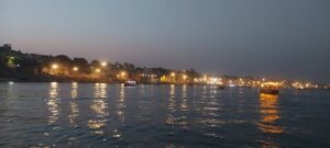
The Maha Arati at the night remain a powerful instrument where people link themselves with the Lord of the Lords, Lord Shiva. Varanasi is the city of Lord Shiva and hence a trip around various ghats give you different notions about life and death. It is an amazing feeling once you are witnessing the entire process particularly when you pass through the Harishchandra Ghat and Dashashmegh ghat where funeral pyres burnt all through day and night. A few moments near it and one can understand the whole process of life, death and meaning of life.
While the ghats are lively in Varanasi yet the water is reduced and the quality remain questionable. A study conducted by ‘The findings of the present study revealed that the concentration of physicochemical parameters in the water of the River Ganga was higher downstream than it was upstream, indicating that River Ganga at Varanasi is negatively impacted by activities such as discharge of domestic sewage, open drain, and agricultural and industrial effluents because of extensive urbanization. The water quality of Ganga was degraded to the level that it was unsafe for bathing. [11]The Ganga River in Varanasi is severely polluted because of the discharge of polluted water through various sources, resulting in poor water quality that is unsuitable for human consumption, including drinking and bathing at most of the ghats’.
The boatman who took me to various ghats was never amused by my points of pollution in the river. ‘Ganga maiya ka paani kabhi kharab nahi hota’, and he just put one hand into the river and took the water chanting ‘Ganga maiyaa ki jai’.
Varanasi has been an abode of diverse ideologies living together. It is considered to be city of Lord Shiva though at Rajghat where Varuna finally ends its journey in Ganga, a number of Nishad community persons, mostly boatmen, blamed the policies of the government. Crores of rupees have been spent for ‘cleaning Ganga’ yet it remains polluted. ‘Varuna is full of sewage water. All the garbage of the city is being brought in the boat here and flown into the river. The stink is so high that it is difficult to stand nearby. The fish catch has reduced drastically’, they said.
Varanasi is one of the most ancient cities of the world, city of Lord Shiva. Various saints came here to liberate themselves. Brahmanical rituals also flourished here but equally important is the counter revolution that happened in Varanasi with its becoming important Centre of Buddhism apart from the birth places and ‘karmbhumi’ of great saints such as Ravidas and Kabir. Revolutionary, Ravidas challenged superstition prevailing that time in the name of customs and culture as well as caste-based hierarchy, was born in Kashi. Ravidas spoke of Begumpura, a truly socialist society based on equality of human being. ‘man changa to kathauti me Ganga’ which roughly translate as if your heart is clean and good then you can see Ganga in your bucket.’ Another legend from Kashi is Saint Kabir who challenged the superstition and culture of caste system. When people would come to Varanasi at the fag-end of their lives, Kabir actually broke that myth which suggested ‘heaven’ to those who die in Varanasi and instead went to Magahar, about 250 kilometers away,where dying was considered a sin.Varanasi is also known to the world over for its great Buddhist heritage. ‘Sarnath is revered as the place where the Buddha delivered his first sermon, known as the ‘Dhammacakkappavattana Sutta’, after attaining enlightenment. It’s one of the four most sacred Buddhist pilgrimage sites in the world.’[12] Thousands of Buddhists as well as those who are influenced by the Buddhist philosophy, travel to Sarnath to see the beautiful stupa and historical site.

About 30 kilometers away from Varanasi city towards Ghazipur, river Gomti merges into Ganga at a village named Kaithi where an ancient temple dedicated to Lord Shiva, known as Markandeya Mahadev Mandir is situated on the confluence of these holy rivers. It’s a beautiful site and hundreds of birds can be seen here particularly during the winters. This place has also become a tourist hub for Dolphin watchers. ‘“As per a survey by the Wildlife Institute of India (WII), there were 21 dolphins in Ganga stretch of Varanasi. Now, as per an assessment, dolphins have increased at the Ganga-Gomti confluence point and there should be 35 to 39 dolphins here at present.”[13]
Thousands of pilgrims travel to this place to take a dip in the river Ganga. Just a few hundred meters away is the confluence of Gomti river with Ganga. Gomti rises from the foothills of Himalayas near Pilibhit and after passing through various places particularly Lucknow and Jaunpur, it finally ends the journey at Kaithi. There is little water in the river which is equally polluted. At the Sangam point, we can walk upto the river. There are numerous white birds but no sign of any dolphine though the local fisherman informs us that it could be sighted in October November. Right now, there is little water so fish catch too is reduced.
Ganga continues to move ahead embracing all the smaller or bigger rivers in it and giving people life. After Varanasi, Ganga passes through Ghazipur and Balia district of Uttar Pradesh and make its entry in Bihar through district Buxar.
There is no dearth of devotees on various ghats of Ganga throughout the state but it is equally painful that there is still not much sensitivity related to purity of water as sewage system and industrial waste continue to be flown into the river. The municipal corporations and big industries continue to violate norms and guidelines. Equally important is that there must be guidelines for devotees and pilgrims too. The depletion of water level in various rivers and the increasing pollution is a grave threat to not only our food security, agrarian system but also to our civilization hence we must protect and respect our rivers, rivulets and various waterbodies.


