
THE ASIAN INDEPENDENT UK
Vidya Bhushan Rawat

The Kho or Khoh River is a major tributary of the Ramganga, originating in Uttarakhand. Official records cite its source in the forests of Langur Patti, but in reality, the river’s journey begins from Dogadda, a historical town in district Pauri Garhwal, Uttarakhand. It is here, after the confluence of the Langurgad and Silgad, that the newly formed river takes the name Kho. Actually, this story of the emergence of a new river is very much like Bhagirathi and Alaknanda meeting at Deoprayag to form Ganga. Dogadda, the birth place of legendry Dr Shiv Prashad Dabral, who wrote numerous volumes on History of Uttarakhand is located at an altitude of over 3000 fts and is actually enclasped by river Langurgad and Silgad as well as surrounded by the Shivalik hills.
Sadly, some claim the Kho originates further ahead from the forests at Dadamandi-Dwarikhal but accepting this would render the historically significant Langurgad meaningless. Langurgarhi holds a prominent place in Uttarakhand’s history as it was here in 1790 that Garhwali soldiers, after a year of fierce fighting, forced the invading Gurkha forces to retreat. The site lies about 25 km from Dogadda town, at an altitude of roughly 2,700 meters. Langur-gad is named as it actually is sourced from the forests in the Langur Patti or Languri or Langurgarhi and its adjoining forests. It ends its journey traversing nearly 20 kilometers to a scenic place of Dogadda where it meets the other river emerging from Sila village forests near Lansdown. The new river emerge out of this confluence is known as Kho or Khoh.
Dogadda has long been a culturally and politically important town in Uttarakhand. It deserves official recognition as the origin point of the Kho River like Devprayag, the sacred confluence of the Alaknanda and Bhagirathi. The Uttarakhand government should take a clear decision on this matter by officially acknowledging Dogadda as the source place of river Khoh and ask the local bodies there to act fast to preserve its beautiful confluence.
 The most important thing is that both these tributaries, Langurgarh and Silgarh, carry water year-round and are not mere seasonal streams. During the monsoon, they turn fierce and aggressive, carrying tons of stones and boulders. Nothing can stand against their force. Having grown up in Dogadda, my birthplace, I am witness to its beauty as well as fury since my childhood when these rivers ran crystal clear and their gentle murmuring turning into a roar during the rains. But today, when I look at Langurgad towards Dadamandi or Silgad towards Lansdowne, I actually feel depressed at their ‘plight’. They were the place where we really enjoyed walking around and watching their powerful fury during the monsoon. How, we would debate among ourselves as which is bigger or which carries more water and devastation.
Today, large resorts have taken over the riverbanks. Water is blocked at multiple points to create recreational pools for tourists. People drive their Thars and other SUVs straight into the riverbeds. The river’s entire character has changed. Uncontrolled mining has inflicted further damage. It is extremely painful to see big vehicles being washed on the river and passing through it at various places.
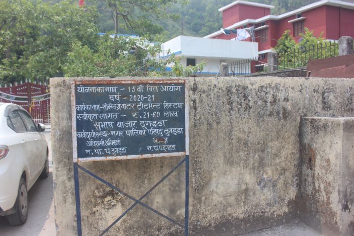
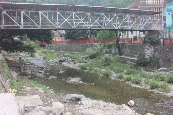
Visiting the confluence at Dogadda filled me with sorrow. This was once our childhood playground, where we watched the rivers swell with terrifying power during monsoons. Today, people stand inside both Silgad and Langurgad, blocking the flow to create private pools. The growing number of riverside resorts is making the problem worse. By the time the water reaches the main confluence, the situation is even more dire. At the junction, Silgad barely has any visible flow. Grass has overgrown the area, and sewage from nearby markets flows directly into it. A sign at the municipal sewerage plant claims ₹21 lakh was spent, yet locals say the untreated waste continues to pollute the river at the confluence.
 Can the local municipality and Uttarakhand government not stop unauthorized constructions along the riverbanks to keep it alive? Can they not organize cleaning drives with community help? Mountain rivers particularly those we term as smaller ones, are inherently beautiful and they might be smaller but they have life and energy. Their clear, babbling waters reflect their vitality. Small rivers like these stay closer to farmers and local communities because they are directly linked to daily life. Farmers draw water easily from them, and people once bathed in natural deep pools known locally as *Dhandi*. Those natural pools have now vanished. Outsiders have built stone walls across the rivers, artificially altering their flow and character. Water is dammed everywhere so tourists can lounge for hours. Riverside resorts are drawing more visitors, turning the rivers into venues for parties and recreation.
After the confluence of Langurgad and Silgad at Dogadda, the newly formed Kho River flows towards Kotdwar, a town at the distance of about 10 kilometer. The stretch between Dogadda and Kotdwar is particularly scenic: the river winds through massive rocks and boulders. Because the riverbed is not easily accessible, the water remains remarkably clean. Dogadda’s famous Durga temple provide a beautiful view of the river carving its way through huge rocks. This section also serves as a vital watering point for wild elephants. Herds are frequently spotted here, as the area forms an important part of Rajaji National Park.
By the time the Kho reaches Siddhbali temple in Kotdwar, its condition deteriorates. The river splits into several channels — some naturally, others turned into small bathing pools by visitors. Tourists throng the area. Men, women, and children search for spots to bathe. The riverbed is full of stones brought down during monsoon floods. Beyond Kotdwar, the river reaches Saneh Park and Saneh Road, marking the beginning of its journey through the plains. By now, it has been joined by a couple of local streams and appears fuller. Saneh Road, located on the Najibabad-Kotdwar railway line, lies in a forested zone frequented by wild animals and remains remarkably scenic.
In its final stretch, the Kho River crosses several small towns in Bijnor district of Uttar Pradesh. After traveling approximately 112 kilometers, it merges with the Ramganga River at Latifpur Bila (or Latifpur Ba) village in Dhampur tehsil. Honestly speaking, at the confluence, the Kho often appears larger than the Ramganga. This is because a massive dam at Kalagarh upstream drastically reduces the Ramganga’s flow, with water released only through barrages at a few points.
 Interestingly, a barrage has also been constructed on the Kho River at Sherkot, about 25 km before the confluence. From here, an 82-km-long feeder canal supplies water to the Ganga. The main Ganga flows from Haridwar through Bijnor to Garhmukteshwar. At Haridwar’s Bhimgoda barrage, most of the Ganga’s water is diverted into the Upper and Lower Ganga Canals. The “divine” waters seen at ‘Har ki Pauri’ is actually canal water. The real, depleted Ganga can be seen near Chandi Ghat bridge, where the riverbed often lies almost dry. After Haridwar, the Ganga enters Uttar Pradesh at village Balawali in Bijnor district. Its course from Bijnor to Garhmukteshwar remains largely dry except during the monsoon.
This drying of rivers is devastating agriculture. While large canals serve thousands of villages, fields along the natural river courses suffer severe water scarcity. At Garhmukteshwar Ganga water gets life from the direct water of Kho River released from Sherkot Barrage through its feeder Canal. Every day, 535 cusecs of water from the Sherkot Kho barrage travels through 82 kilometres long canal and merges with the Ganga at Tigri Ghat near Garhmukteshwar, helping keep the river alive in that region. However, excessive human interference with river waters — largely in the name of agriculture — is fundamentally altering their character and causing ecological damage. We have actually moved forward today as these rivers are increasingly being managed only to meet religious and tourism needs at specific ghats and pilgrimage sites, while water for farming continues to decline due to climate change, rampant mining, and illegal construction of resorts and hotels along mountain streams. In effect, our rivers are being converted into entertainment zones, severing their vital connections with local communities, farmers, and indigenous people to cater to urban elite desires.
While the Kho River breathes new life into the Ganga near Garhmukteshwar, its main channel meets the Ramganga about 28 km away at Latifpur Bila Ahatmali in Dhampur tehsil. Even here, multiple barrages on the Ramganga (after the Kalagarh dam) leave it depleted — and once again, the Kho revives it. The Ramganga then flows through Moradabad and Shahjahanpur before joining the Ganga at Hardoi, where the confluence area also resembles a desert. Further downstream, water reappears at Bithoor (22 km before Kanpur) due to yet another barrage, making Bithoor an important religious and recreational spot, while Kanpur’s stretch is dominated by sand mining.
Reaching Confluences is Extremely Difficult
In the plains, accessing river confluences — except at major religious sites — is very challenging. Reaching the Kho-Ramganga or Ramganga-Ganga confluence requires great patience and effort; many places are accessible only on foot or by tractor. As these are not religious places hence none is bothered about the confluence of the rivers. At the Sherkot barrage on the Kho, grass has overgrown the area and water is barely visible. At Latifpur Bila, the path to the confluence is covered in dust and sand. I attempted to reach it twice in the scorching afternoon heat but failed. A farmer from the Saini community, seeing our struggle, kindly offered to take me on his tractor. The ride was perilous across the sandy, pitted terrain reflecting the flooded area in the monsoon. During the journey, he shared that most locals belong to Dalit and extremely backward communities. He criticized the government for harming farmers and expressed faith in the BSP, while noting that bigger farmers in the area support the BJP. He also mentioned that annual floods from these rivers regularly destroy crops. This year, with no rain yet, only sugarcane survived. Even if rain arrives late, farmers stand to gain little. Remarkably, despite both rivers flowing through the fields, local agriculture remains heavily dependent on rainfall. It unambiguously means that farming communities living on the bank of the rivers only get devastation due to flood and nothing in normal time. During monsoon, the canals are protected and the original rivers get the fury resulting in the water crossing to the nearby fields and destroying the crop, livestock and human life.
The Crisis Facing the Kho River
The Kho is a relatively small river, yet it has sacrificed much of its own identity to sustain the larger Ganga and Ramganga systems. It supplies water to Dogadda and Kotdwar towns and remains a vital cultural lifeline for local communities. In Uttar Pradesh, the barrage on the Kho irrigates hundreds of villages in Bijnor and Moradabad districts.
Tragically, the very river that gives life to the Ganga and Ramganga — and supports countless farmers — is under severe threat at its source. Both the Uttarakhand and Uttar Pradesh governments must act urgently, working with local communities, municipalities, and panchayats. Immediate steps are needed to:
– Ban all mining on the Kho River
– Stop the unnatural blocking of water in the river and its tributaries
– Take legal action against illegal resorts and hotels along its banks
Saving the Kho River also means protecting the wildlife habitats of Rajaji National Park and the Kalagarh forest division. Kho river’s ecological and environmental importance can be visualised both right from its beginning till it ends its journey. At places like Dogadda the ground water was available very easily. At the time, when a majority of the hill as well as Tarai regions of Uttarakhand suffer from Potable water crisis, towns like Dogadda were actually heaven for all. The water quality here was extraordinary and people never needed refrigerators in the past as water remained cold during the summer and warm in the winter.
It is time to protect and preserve river kho so that it continues to give us life and energy.


